Publisher:
Bonnie King
CONTACT:
Newsroom@Salem-news.com
Advertising:
Adsales@Salem-news.com

~Truth~
~Justice~
~Peace~
TJP
Oct-31-2010 15:00

 TweetFollow @OregonNews
Oregon Department of Geology and Mineral Industries Showcase New Ways to Visualize the Effects of Floods and Landslides
Salem-News.com
 www.OregonGeology.org |
(DENVER, Co) - This morning, Oregon Department of Geology and Mineral Industries Chief Scientist, Ian P. Madin, lead an internationally attended Pardee Keynote Symposium on amazing new advances in mapping the earth's surface using imagery generated using a laser based terrain mapping program called LiDAR (light detection and ranging), at the Geological Society of America annual conference, at the Colorado Convention Center in Denver.
Pardee Keynote Symposia are special, interdisciplinary events representing the leading edge of a scientific discipline or area of public policy.
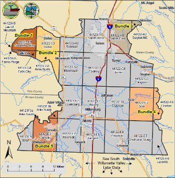
"Seeing the True Shape of Earth's Surface: Applications of Airborne and Terrestrial LiDAR in the Geosciences" featured some of the cutting edge land surface imagery that Mr. Madin and the staff at DOGAMI are developing for Oregon including new ways to visualize the effects of floods and landslides to Oregon cities.
Madin and scientists from around the world explored the breadth of applications for high resolution LiDAR imaging of the land, water and vegetation. New data processing techniques are putting incredibly detailed models and images of the surface of Earth into the hands of geoscientists aroundd the world.
This session explored the application of airborne and terrestrial LiDAR to topics including paleoseismology, neotectonics, salt marsh ecology, lava flow morphology, post-fire slope processes, engineering geology, rockfalls and debris flows, geologic mapping, forestry, coastal processes and stream channels. The session also encouraged participants to think of new ways to apply this exciting technology to their own areas of study.
To learn more about seeing landslide with lidar in Oregon, go online at: www.oregongeology.org/pubs/Cascadia/CascadiaFall2006.pdf, and at: www.OregonGeology.org
The Pardee Keynote Symposia are made possible by a grant from the Joseph T. Pardee Memorial Fund.
Source: Oregon Dept. of Geology and Mineral Industries
Articles for October 30, 2010 | Articles for October 31, 2010 | Articles for November 1, 2010


Quick Links
DINING
Willamette UniversityGoudy Commons Cafe
Dine on the Queen
Willamette Queen Sternwheeler
MUST SEE SALEM
Oregon Capitol ToursCapitol History Gateway
Willamette River Ride
Willamette Queen Sternwheeler
Historic Home Tours:
Deepwood Museum
The Bush House
Gaiety Hollow Garden
AUCTIONS - APPRAISALS
Auction Masters & AppraisalsCONSTRUCTION SERVICES
Roofing and ContractingSheridan, Ore.
ONLINE SHOPPING
Special Occasion DressesAdvertise with Salem-News
Contact:AdSales@Salem-News.com
Terms of Service | Privacy Policy
All comments and messages are approved by people and self promotional links or unacceptable comments are denied.
[Return to Top]
©2025 Salem-News.com. All opinions expressed in this article are those of the author and do not necessarily reflect those of Salem-News.com.