Publisher:
Bonnie King
CONTACT:
Newsroom@Salem-news.com
Advertising:
Adsales@Salem-news.com

~Truth~
~Justice~
~Peace~
TJP
Oct-25-2022 13:49

 TweetFollow @OregonNews
Wildfire Near Oakridge Still Burning After Over 75 Days
Salem-News.comThe wildfires in Oregon are not "over".
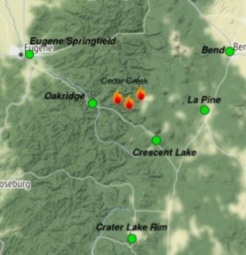
 Map issued by Wildland Fire Air Quality Response Program (Oct 25, 2022) |
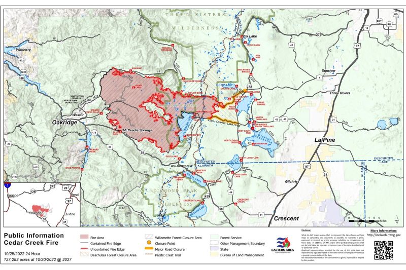
(SALEM, Ore.) - Oregon's Cedar Creek fire has been burning since August 1st. As of 5:30 a.m. today, there are 301 firefighting personnel working to contain the wildfire, east of Eugene. The fire remains at 127,283 acres and 55% contained.
Air quality conditions due to smoke are expected to range from good to moderate within the forecast area. Air quality yesterday was Good across the Outlook Area with exception of Oakridge.
Drift smoke from smoldering fuels managed to make its way into Westfir/Oakridge and along the Highway 58 corridor for a short period, nudging air quality into Moderate.
Today, there’s another chance smoke may do so again late this afternoon before the rain/snow moves back in this evening. A short drying trend predicted Thursday through Sunday will provide an opportunity for exposed fuels to generate more smoke.
Resources currently assigned to the Cedar Creek fire include 4 Engines, 5 Hand crews, 4 Masticators and 1 Helicopter.
Weather:
The western side of the Cedar Creek Fire received over half an inch of rain yesterday, with the eastern side receiving around two tenths of an inch.
Today, a break in the wet weather is expected until later in the day when the next weather system arrives from the Pacific.
Rain estimates are between one quarter and three quarters of an inch for the west side and once again less on the east side. Temperatures will be in the 40’s with the snow level dropping to 4000 feet.
Rain and mountain snow is set to move back in this evening and overnight. Heaviest precipitation seems to be around midnight with rain totals nearing half an inch again on the western slopes. Snow levels will drop to around 4000 feet with 5 to 8 inches possible overnight.
Tonight’s incoming precipitation will continue to cool active fire conditions. Pockets of heat remain within the fire’s interior, causing isolated smoldering across the burn area. Showers linger into early Wednesday afternoon and then some drying comes in.
Expected fire behavior is best described as... smoldering.
Operations:
With several days of variable amounts of rain received and in the forecast, travel routes to the fireline and safe working conditions will be closely monitored for firefighter health and safety.
Where conditions are conducive to working effectively and safely along the fireline, suppression repair efforts will be conducted to help combat erosion near the fire area.
Closures:
Reduced closures are in effect on both the Deschutes National Forest and Willamette National Forest. These closures will remain in place until areas impacted by the fire are surveyed for safety risks and fire crews are able to mitigate these hazards.
Please visit Willamette National Forest and Deschutes National Forest for the most recent closure orders and maps.
Pacific Crest Trail hikers should visit pcta.org for current information.
The Temporary Flight Restriction over the Cedar Creek Fire area has been lifted due to a reduction of aircraft needs for fire operations.
Please respect Forest closures for firefighter and public safety.
Evacuations:
The level 1 Evacuation Order has been lifted in Westfir, Oakridge, and the High Prairie area. The remaining evacuations for Lane County have been lifted.
Please check with Lane County Sheriff’s Office at 541-682-4150 and Deschutes County Sheriff’s Office at 541-693-6911 for updates and changes.
For current AIR QUALITY conditions, see Fire.airnow.gov, oakridgeair.org, and LRAPA- Today's Current Air Quality.
Smoke Forecast Outlooks are available at https://outlooks.wildlandfiresmoke.net/outlook. Also, check out the Cedar Creek Fire facebook page.
Stay vigilant. The wildfires in Oregon are not "over".

Source(s): Oakridge Air; Lane Regional Air Protection Agency; AirNow Fire and Smoke Map; Interagency Wildland Fire Air Quality Response Program; others.
Articles for October 24, 2022 | Articles for October 25, 2022 |


Terms of Service | Privacy Policy
All comments and messages are approved by people and self promotional links or unacceptable comments are denied.
[Return to Top]
©2025 Salem-News.com. All opinions expressed in this article are those of the author and do not necessarily reflect those of Salem-News.com.