Publisher:
Bonnie King
CONTACT:
Newsroom@Salem-news.com
Advertising:
Adsales@Salem-news.com

~Truth~
~Justice~
~Peace~
TJP
Oct-08-2012 14:22

 TweetFollow @OregonNews
Newport, Oregon to Hold Tsunami Evacuation Drill Oct. 11
Salem-News.comThe challenge of safely escorting several hundred people across the Oregon Coast’s busiest highway has become a community-wide effort.
 Newport, Oregon to Hold Tsunami Evacuation Drill Oct. 11 |
(NEWPORT, OR) - Growing awareness of the potential dangers of a major earthquake and tsunami has prompted Oregon State University and community leaders in the coastal town of Newport to expand the scope of their annual tsunami evacuation drill.
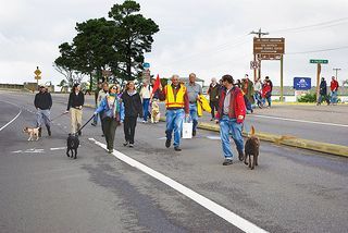
OSU’s Hatfield Marine Science Center is coordinating the exercise, which will begin at 10:18 a.m. on Thursday, Oct. 11. Several hundred participants are expected from OSU and the federal and state agencies co-located on the South Beach peninsula, and well as employees and residents from adjacent locations. As part of the drill, Highway 101 will close for five minutes.
The OSU Hatfield Marine Science Center is located on Newport’s South Beach Peninsula, a growing hub for marine science research and applications – and right in the tsunami inundation zone. The area also includes the new NOAA Marine Operations Center – Pacific, the Port of Newport’s public marina, the Oregon Coast Aquarium and headquarters for Rogue Ales.
George Boehlert, director of the Hatfield Marine Science Center, said the 300 or so employees at the center are well aware of tsunami dangers. In fact, NOAA and OSU scientists located there conduct cutting-edge research on tsunamis and subsea earthquakes and volcanoes and they helped prompt the first drills, which last year were expanded to include all of the South Beach Peninsula neighbors.
The closest high ground for many South Beach peninsula workers and residents is a hill just west of the entrance to the Yaquina Bay Bridge. Dubbed “Safe Haven Hill”, the Oregon Department of Transportation-owned property is more than 85 feet high and estimated to accommodate several thousand people if necessary.
Although it is possible to reach the top, the hill appears overgrown and inaccessible, with access limited to two rough, steep trails. The City of Newport is aggressively pursuing grant funding to increase access.
“Safe Haven Hill serves as a critical assembly point for South Beach Peninsula evacuees, and making it accessible to as many people as need it is a high priority for us,” said Newport Mayor Mark McConnell. “HMSC has been a great partner, and their activities have helped the city jump-start our outreach efforts to other neighborhoods within the inundation zone.”
Maryann Bozza, program manager for the OSU center and organizer of the drill, said the goal in last year’s exercise was “to reach our actual evacuation point, which is the top of the hill at 85 feet, and build confidence in our staff that we can achieve 85 feet of elevation in 15 minutes.”
“This year we'll take the next step and throw in some obstacles, which are likely after a large earthquake,” Bozza said. “Evacuees may not be able to make a bee line for the top of the hill, so they need to be aware of alternate routes."
The challenge of safely escorting several hundred people across the Oregon Coast’s busiest highway has become a community-wide effort. A team led by Newport Police Officer Tom Lekas includes the Newport Police, Newport Police Volunteers, Lincoln County Emergency Management, Newport Fire Department, Community Emergency Response Team (CERT) members, Oregon Emergency Management and Oregon Department of Transportation.
“The road closure is an inconvenience to drivers, but it is a key component of a realistic drill,” said Boehlert. “The only other route to Safe Haven Hill passes under the Yaquina Bay Bridge, which is likely to be down or unsafe after a major earthquake.”
The Oct. 11 drill will begin at 10:18 a.m., with a highway closure of less than five minutes in both directions planned for about 10:30 a.m. Several hundred participants are expected and the entire drill is expected to last one hour.
A second drill will occur on Thursday, Oct. 18, in conjunction with the statewide Great Oregon Shakeout drill, scheduled for “10/18 at 10:18.” At that drill, South Beach Peninsula participants will walk to the Oregon Coast Community College hill, which is a mile away and serves as an alternate evacuation point for South Beach peninsula employees. No highway closures are planned for that day.
About OSU's Hatfield Marine Science Center: The center is a research and teaching facility located in Newport, Ore., on the Yaquina Bay estuary, about one mile from the open waters of the Pacific Ocean. It plays an integral role in programs of marine and estuarine research and instruction, as a laboratory serving resident scientists, as a base for far-ranging oceanographic studies and as a classroom for students. Its campus includes research activities and facilities from six different state and federal agencies.
Articles for October 7, 2012 | Articles for October 8, 2012 | Articles for October 9, 2012
Quick Links
DINING
Willamette UniversityGoudy Commons Cafe
Dine on the Queen
Willamette Queen Sternwheeler
MUST SEE SALEM
Oregon Capitol ToursCapitol History Gateway
Willamette River Ride
Willamette Queen Sternwheeler
Historic Home Tours:
Deepwood Museum
The Bush House
Gaiety Hollow Garden
AUCTIONS - APPRAISALS
Auction Masters & AppraisalsCONSTRUCTION SERVICES
Roofing and ContractingSheridan, Ore.
ONLINE SHOPPING
Special Occasion DressesAdvertise with Salem-News
Contact:AdSales@Salem-News.com

googlec507860f6901db00.html


Terms of Service | Privacy Policy
All comments and messages are approved by people and self promotional links or unacceptable comments are denied.
[Return to Top]
©2025 Salem-News.com. All opinions expressed in this article are those of the author and do not necessarily reflect those of Salem-News.com.