Publisher:
Bonnie King
CONTACT:
Newsroom@Salem-news.com
Advertising:
Adsales@Salem-news.com

~Truth~
~Justice~
~Peace~
TJP
May-15-2008 09:45


 TweetFollow @OregonNews
West Coast Sizzles, While Flooding Threatens Eastern States
Salem-News.comWarm days for Oregon and California.
 Courtesy: AccuWeather.com |
(SALEM, Ore.) - While it is not yet summer, it feels like it as record heat is building along the West Coast, and weather in along the eastern side of the nation is seeing drenching downpours and strong storms will continue today along the Gulf Coast.
West Coast Sizzles
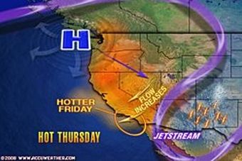
Daily temperature records will be shattered over the next couple of days as heat spreads into the Intermountain West and central Rockies, forecasters at Accuweather.com say. The heat in the Northwest will peak Friday, with highs as much as 30 degrees above normal for mid-May.
West Coast Expert Meteorologist Ken Clark reports the heat will stick around into next week. "For the Central Valley, and especially San Joaquin Valley, high heat is likely through the weekend and even next Monday. In the deserts of Southern California and Arizona, the hottest weather does no even occur until Sunday and Monday."
The retreat of the jet stream into western Canada will allow hot air to flow freely out of the Southwest as far north as the Pacific Northwest and southern British Columbia. Offshore winds that pump hot desert air into the Los Angeles Basin and other areas along the California coast will cause some other problems as well. Operators of high profile vehicles will have to deal with gusty crosswinds in the canyons and passes, while hot winds elevate the fire danger.
Not Yet Summer Temperatures in East as Flooding Rain Threatens Many Areas
The positioning of the jet stream across the central Plains will keep the heat out of the eastern half of the country. After a couple of days of near-normal temperatures, highs in the East through the middle of next week will dip slightly below normal for mid-May.
According to the AccuWeather.com Severe Weather Center, locally severe thunderstorms will erupt today from the central Gulf Coast to the Tennessee Valley as the storm system that pounded the Arklatex over the past couple of days will move across the South today. Strong thunderstorms will erupt south of the storm track while a steady rain falls to the north. In contrast to the severe storms of the past couple of weeks, the greatest threat today will be flooding rain.
Rain will again reach the Mid-Atlantic States by this evening where it will linger over the region into Friday, with rain falling heavily at times. The combination of the additional rain and high tides will increase potential for coastal flooding around the Chesapeake Bay, where flood watches and warnings have been issued. Northern Virginia and Maryland are especially vulnerable to flooding after recent heavy rain. Washington, D.C. has received over 450 percent of the rain that typically falls during the first half of May.
Source: AccuWeather.com
Articles for May 14, 2008 | Articles for May 15, 2008 | Articles for May 16, 2008
Salem-News.com:


Terms of Service | Privacy Policy
All comments and messages are approved by people and self promotional links or unacceptable comments are denied.
[Return to Top]
©2025 Salem-News.com. All opinions expressed in this article are those of the author and do not necessarily reflect those of Salem-News.com.