Publisher:
Bonnie King
CONTACT:
Newsroom@Salem-news.com
Advertising:
Adsales@Salem-news.com

~Truth~
~Justice~
~Peace~
TJP
May-05-2011 18:13

 TweetFollow @OregonNews
The State of Oregon Publishes Interactive Broadband Availability Map
Salem-News.comOregon has secured federal funding for this project through 2014
 |
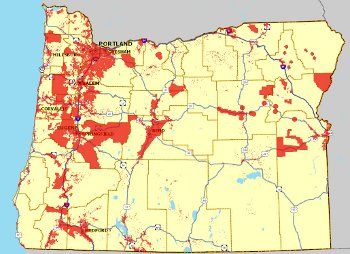
(Salem, Oregon) - A statewide on-line interactive map where users can find broadband coverage information for the entire state is now live. Customers can run speed tests, find community anchor institutions and print the results.
The new broadband mapping website enables Oregon’s residents and businesses to determine their broadband service providers and options and to understand their actual upload and download speeds.
“Individuals can enter their address and receive a listing of broadband service providers reporting to serve them. Additional information available includes the various broadband technologies as well as general broadband coverage information for a given area,” OPUC Telecommunications Administrator Bryan Conway said. “To get the most from the site I encourage people to read the tutorials and then jump in find out what the website has to offer.”
The broadband map is generated using data about service availability collected from broadband providers, such as where their broadband facilities are located and the technology used. The availability of broadband service is shown at a census block level for census blocks less than 2 square miles, and by street segment for census blocks greater than 2 square miles. The accuracy of the map should improve over time as more broadband providers share their data and users provide us information as well.
“As more people use the site and provide feedback, I expect the accuracy of the map to improve,” Conway added. Users should provide feedback by using the “Comment Tool” on the state map.
In December 2009, the state received a $2.1 million American Recovery and Reinvestment Act (ARRA) grant to fund the broadband data gathering and mapping effort.
The state will submit updated broadband data twice a year to the Department of Commerce. However, Oregon’s statewide map will be updated more frequently. Oregon has secured federal funding for this project through 2014.
The Oregon Public Utility Commission, the Oregon Department of Administrative Services, the Oregon Business Development Department and other state and subcontractor organizations contributed to the development and implementation of this project.
View the broadband map for Oregon at http://www.oregon.gov/broadband/
Source: Oregon Public Utility Commission
Articles for May 4, 2011 | Articles for May 5, 2011 | Articles for May 6, 2011
Quick Links
DINING
Willamette UniversityGoudy Commons Cafe
Dine on the Queen
Willamette Queen Sternwheeler
MUST SEE SALEM
Oregon Capitol ToursCapitol History Gateway
Willamette River Ride
Willamette Queen Sternwheeler
Historic Home Tours:
Deepwood Museum
The Bush House
Gaiety Hollow Garden
AUCTIONS - APPRAISALS
Auction Masters & AppraisalsCONSTRUCTION SERVICES
Roofing and ContractingSheridan, Ore.
ONLINE SHOPPING
Special Occasion DressesAdvertise with Salem-News
Contact:AdSales@Salem-News.com

googlec507860f6901db00.html


Terms of Service | Privacy Policy
All comments and messages are approved by people and self promotional links or unacceptable comments are denied.
[Return to Top]
©2025 Salem-News.com. All opinions expressed in this article are those of the author and do not necessarily reflect those of Salem-News.com.