Publisher:
Bonnie King
CONTACT:
Newsroom@Salem-news.com
Advertising:
Adsales@Salem-news.com

~Truth~
~Justice~
~Peace~
TJP
Mar-15-2008 11:00

 TweetFollow @OregonNews
No Tsunami Threat From Oregon Earthquake
Bonnie King Salem-News.comHistorically, there have been quite a few earthquakes that changed Oregon, luckily this wasn't one.
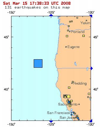
 Map: USGS |
(SALEM, Ore.) - There was a big rumble out in the ocean this morning. The 5.9 magnitude earthquake struck about 112 miles west of Port Orford, at 7:44 AM PT. Luckily, it didn't cause enough of a stir to set off tsunami warnings in Oregon's coastal towns.
The quake was a depth of 6.2 miles, according to Angel Gutierrez, a geophysicist with the U.S.Geological Survey in Golden, Colorado. The USGS initially put the quake at 6.0 magnitude.
They say the quake was relatively shallow, about 6 miles down, and no tsunami alert was issued as a result.
Experts say minor earthquakes are common in this region of the Pacific Ocean, along the Cascadia subduction zone, off the coast of Oregon.
Historically, there have been quite a few earthquakes that changed Oregon.
In 1941, a major earthquake (magnitude 7.0) caused eight deaths and an estimated $25 million damage at Olympia, Washington, and a broad area around the capital city. In Oregon, there was also widespread damage, and several people suffered injuries at Astoria and Portland. A maximum intensity of "VIII" was experienced at Clatskanie and Rainier, where many chimneys twisted and fell, and there was considerable damage to brick and masonry.
There was similar damage in Salem on November 16th, 1957, from an earthquake felt over a land area of 11,600 square kilometers in northwestern Oregon. The tremor frightened all in the city, but reportedly only caused some cracked plaster in West Salem.
On August 18, 1961, another earthquake caused minor damage at Albany and Lebanon, south of the 1957 center. The magnitude 4.5 shock, a "VI" was felt by all in the two cities. Portland experienced another moderately strong shock on November 6, 1961.
In 1968, a series of earthquakes near the Oregon-California border began on May 26th and continued daily through June 11th. The total felt area in the two States covered 18,000 square kilometers.
But most commonly referred to is the 1993 "Scotts Mills earthquake", a 5.6 quake that hit Oregon in the early morning of March 25th. It was the largest earthquake in the Pacific Northwest since the Elk Lake and Goat Rocks earthquakes of 1981. The Scotts Mills mainshock epicenter was located at about 5 km east of the town of Scotts Mills, and about 54 km south of Portland.
Ground motion was widely felt in the Willamette Valley, to the Oregon Coast, and even the Puget Sound Basin, with felt reports from Roseburg, Oregon, to as far north as Seattle, Washington.
The USGS detected nearly 200 aftershocks from the Scotts Mills quake, and believed there to be sufficient data to reliably locate epicenters for 149 of the aftershocks.
Clearly, earthquakes do not equate tsunamis, but it is good to know our systems are in place should it be a threat, in the future.
Articles for March 14, 2008 | Articles for March 15, 2008 | Articles for March 16, 2008

Quick Links
DINING
Willamette UniversityGoudy Commons Cafe
Dine on the Queen
Willamette Queen Sternwheeler
MUST SEE SALEM
Oregon Capitol ToursCapitol History Gateway
Willamette River Ride
Willamette Queen Sternwheeler
Historic Home Tours:
Deepwood Museum
The Bush House
Gaiety Hollow Garden
AUCTIONS - APPRAISALS
Auction Masters & AppraisalsCONSTRUCTION SERVICES
Roofing and ContractingSheridan, Ore.
ONLINE SHOPPING
Special Occasion DressesAdvertise with Salem-News
Contact:AdSales@Salem-News.com

Salem-News.com:
googlec507860f6901db00.html

Terms of Service | Privacy Policy
All comments and messages are approved by people and self promotional links or unacceptable comments are denied.
Coastal refugee March 15, 2008 11:30 am (Pacific time)
What about damages along the coast? Please keep us up to date. Thanks!
[Return to Top]©2025 Salem-News.com. All opinions expressed in this article are those of the author and do not necessarily reflect those of Salem-News.com.