Publisher:
Bonnie King
CONTACT:
Newsroom@Salem-news.com
Advertising:
Adsales@Salem-news.com

~Truth~
~Justice~
~Peace~
TJP
Mar-03-2011 01:30

 TweetFollow @OregonNews
The Secrets of Mt. Hebo
JD Adams Salem-News.comEchoes of the past are fading slowly on the windy summit of Mt. Hebo.
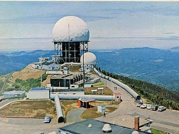
 Back in 'the day' - Radars at Hebo 66. by Steve Weatherly |
(MT. HEBO, Ore.) - Mount Hebo rises abruptly to an elevation of 3,176 ft. in the Northern Oregon Coast Range on the border between Tillamook County and Yamhill County.

It's proximity to the Pacific Ocean makes it an outstanding viewpoint and also made it a logical location for an Air Force General Surveillance Radar Station that was active from 1956 to 1980.
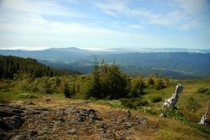
The lofty height of Mt Hebo places it in a climate zone of lingering snow and gnarled, windswept trees, with other plant life usually found on the slopes of the Cascade Range. The steep sides of the mountain create the stunning impression of being in a lost world surrounded by panoramic views and distant peaks.
Mt. Hebo's summit is graced by grassy meadows that beckon with leisurely abandon during the summer months, and the curving horizon of the Pacific Ocean can be seen from westward vistas.
From the Hebo Lake Campground the Pioneer-Indian Trail travels toward the summit meadows and North Lake, and then descends to South Lake for a total length of eight miles.
This trail has been reclaimed from obscurity, once being used by Coastal Indians for traveling between the Tillamook area and the Willamette Valley.
 Mt. Hebo today. Photo courtesy: Wikipedia |
Oregon pioneer Hiram Smith and other Tillamook settlers improved the trail in 1854, and it was an important route until a wagon road was completed in 1882.
In 1975 the trail was rediscovered by Forest Service employee Leonard Whitmore, who noted several sections that were still discernible because of years of horse travel.
The Pioneer-Indian trail was rebuilt in 1984, and now serves as a scenic reminder of the historic legacy of Oregon's Native Inhabitants and pioneers.
The Mt. Hebo Radar Station was manned by the 689th Radar Squadron, and was a component of the Air Force Semi Automatic Ground Environment (SAGE) system for air defense.
The detection and identification of incoming aircraft was enabled through communications from Mt. Hebo linking the SAGE computers at Oregon's Adair Air Force Station with the McChord Air Force Base in Washington, employing the supersonic F-106 Delta Dart for the interception and destruction of enemy aircraft, if necessary.
War veterans that lived in Willamina and other nearby coastal towns have stories that indicate there was more going on at Mt. Hebo than was reported to the public.
One source has admitted that he was commanded to take daily military flights from Portland into the coast range while blindfolded.
The flights took about an hour, and he worked 8 hour shifts at an underground location, which he felt was near a missile silo. He reports the location as being Mt. Hebo, although he cannot be certain.
At the eastern summit of Mt. Hebo is a large, flat area that appears to have been a landing strip.
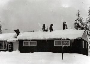
 One of the homes at Mt. Hebo- gone for years |
Other soldiers who lived near Hebo have similar stories, and the next generation of kin have reported seeing huge doors built into slopes about halfway up the mountain.
Some of the roads accessing the doors can still be seen, but the doors themselves were bulldozed over many years ago.
The military radar and interception operations weren't classified; one has to wonder what would have justified blindfolding military personnel.
The fact remains that the west coast faced toward hostile territory during the years of the Cold War.
Echoes of the past are fading slowly on the windy summit of Mt. Hebo.
2.5 miles down from the western summit is a meadow that once contained 27 homes for military personnel.
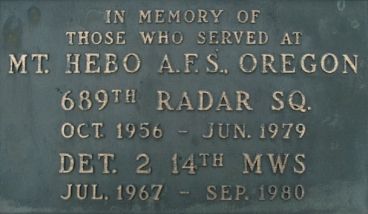
 Memorial to the people who worked at Mt. Hebo |
What was once a small town is being reclaimed by brush.
Replanted trees have erased the scars of past forest fires, but near the top are sun-bleached snags that rise above the meadows like the statues of Easter Island.
At the site of the radar station is a plaque that gives silent testimony to the men and women who lived and worked there:
In Memory of Those Who Served at Mount Hebo AFS, Oregon. 689th Radar Sq., Oct. 1956 - June 1979. Det. 2 14th MWS July 1967 - Sep. 1980".
Sources:
http://en.wikipedia.org/wiki/
http://en.wikipedia.org/wiki/Mount_Hebo_Air_Force_Station
http://www.oregonlive.com/
http://www.fs.fed.us/r6/
_______________________________________________________________________
 J. D. Adams was born in Salem, Oregon, a descendant of Oregon Trail pioneer William Lysander Adams. As a wilderness explorer, photographer, and writer, he sustains a kinship with the spirit of the Oregon country. JD inhabits Oregon's Silicon Forest as an electronics professional with degrees in Electronics Engineering Technology and Microelectronics.
He maintains a Web presence with a signature presentation in genres including travel, history, and technology.
You can write to Jim Adams at this email address: j1mcm0s@earthlink.net
Also, visit Jim's Website: home.earthlink.net/~j1mcm0s/
Articles for March 2, 2011 | Articles for March 3, 2011 | Articles for March 4, 2011
Quick Links
DINING
Willamette UniversityGoudy Commons Cafe
Dine on the Queen
Willamette Queen Sternwheeler
MUST SEE SALEM
Oregon Capitol ToursCapitol History Gateway
Willamette River Ride
Willamette Queen Sternwheeler
Historic Home Tours:
Deepwood Museum
The Bush House
Gaiety Hollow Garden
AUCTIONS - APPRAISALS
Auction Masters & AppraisalsCONSTRUCTION SERVICES
Roofing and ContractingSheridan, Ore.
ONLINE SHOPPING
Special Occasion DressesAdvertise with Salem-News
Contact:AdSales@Salem-News.com

googlec507860f6901db00.html


Terms of Service | Privacy Policy
All comments and messages are approved by people and self promotional links or unacceptable comments are denied.
Avis July 19, 2011 July 19, 2011 1:46 pm (Pacific time)
My parents had the Hebo Sportshop from 1971 until 1996.
Dad's photo album is at the Sport shop now across the street from Dad's old location. The local Hebo store owner is a local historian too.
Editor: Excellent, I have been in your family store many times. In fact, when we were first exploring the story of the crashed B-17 at Cape Lookout for the OPB documentary we later completed in 1993, we dropped in and talked to folks at the store to see what they might know?
Toby March 7, 2011 1:07 pm (Pacific time)
Jim, Interesting stuff.
JDA March 6, 2011 10:52 am (Pacific time)
A remarkable coincidence - Hebo Lake is reopening Monday, March 7th, after a year-long closure during which it was drained, dredged, and re-stocked with fish. The Campground has also been renovated.
[Return to Top]©2025 Salem-News.com. All opinions expressed in this article are those of the author and do not necessarily reflect those of Salem-News.com.