Publisher:
Bonnie King
CONTACT:
Newsroom@Salem-news.com
Advertising:
Adsales@Salem-news.com

~Truth~
~Justice~
~Peace~
TJP
Jul-11-2014 07:04

 TweetFollow @OregonNews
ODOT Launches Real Time Traffic Information in Portland Area
Salem-News.com StaffNational studies show that advisory speed signs have reduced overall crashes by 20 percent, reduced rear-end collisions by 30 percent and reduced secondary crashes by 40 percent.
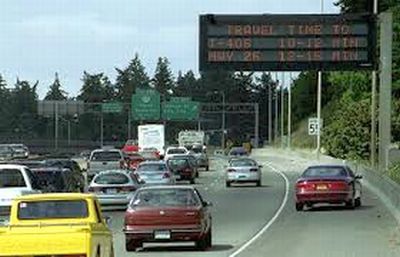
 On Thursday, ODOT launched the first in a series of projects that use new technologies to improve safety, reduce secondary crashes and provide travelers with information to help them safely get to where they are going. Photo Courtesy: Oregon.gov |
(PORTLAND, Ore. ) - On Thursday, ODOT launched the first in a series of projects that use new technologies to improve safety, reduce secondary crashes and provide travelers with information to help them safely get to where they are going.
The ODOT RealTime systems employ sensors in and along the roads that will accurately convey travel times to motorists and establish advisory speed limits that will tell motorists to slow down for a crash, stall or other delay in the road ahead.
“Using technology to improve safety is a cost-effective strategy, especially now, when the funding outlook is uncertain,” said Jason Tell, ODOT’s Region 1 manager.
ODOT RealTime complements the success of the agency’s Tripcheck.com web site and its encouragement to “Know Before You Go.” ODOT RealTime takes this a step further and provides travelers with information while they drive – “Know As You Go.” This system offers information to drivers without the dangerous distraction of operating a smartphone.
On Thursday, ODOT launched the first of three RealTime improvements by activating the travel time signs displayed on 28 variable message signs on Portland area freeways.
Here is a look at the RealTime systems scheduled to get under way this summer.
Travel Time Signs
Launch Schedule: Activated July 10.
Where: On 28 signs throughout the Portland area
What is it? A network of loops and sensors on major Portland-area highways and roads automatically displaying real time travel times, in minutes, on variable message signs. Signs will show the driving time to a major interchange or exit. The information will be displayed on the signs during the day except when other traveler information takes precedence. These signs will help motorists make informed choices on travel plans and routes.
OR 217 Traveler Information
Launch Schedule: Summer 2014.
Where: Along the OR 217 corridor.
What is it? New signs on the highway and on arterials leading to the highway. Highway users will see travel times, advisory speeds and traveler information on seven full-color, LED, 30-foot wide signs, four in the southbound lanes and three in the northbound lanes. There will also be five smaller signs on roads leading to OR 217, including OR 99W, Barnes Road and Kruse Way. These messages will help motorists decide whether to take an alternate route.
Advisory Speed Signs
Launch Schedule: Summer 2014.
Where: On southbound I-5 and I-405 around the Marquam Bridge.
What is it? A series of 15 advisory speed signs on the southbound lanes of I-5 and southbound I-405 around the Marquam Bridge interchange, an area particularly prone to rear-end crashes. When appropriate, these signs will automatically display an advisory speed so motorists will know that they should slow down before reaching a traffic queue ahead caused by a crash, a stall, congestion or other obstruction.
The Interstate 5 and Interstate 405 southbound lanes near the Marquam Bridge interchange and the OR 217 corridor in Washington County have a combination of high-density traffic, changing grades and blind curves. These areas see a high number of crashes and secondary crashes that result in injuries and increased delays.
National studies show that advisory speed signs have reduced overall crashes by 20 percent, reduced rear-end collisions by 30 percent and reduced secondary crashes by 40 percent. For OR 217, that could mean fewer crashes and their associated delays.
Secondary crashes cause serious injuries, costly car repairs, costly medical insurance co-pays and lost time at work and with family.
ODOT is also exploring similar improvements for the Mount Hood corridor on U.S. 26.
Source: Oregon Department of Transportation
 |
Articles for July 10, 2014 | Articles for July 11, 2014 | Articles for July 12, 2014
Salem-News.com:


Terms of Service | Privacy Policy
All comments and messages are approved by people and self promotional links or unacceptable comments are denied.
[Return to Top]
©2025 Salem-News.com. All opinions expressed in this article are those of the author and do not necessarily reflect those of Salem-News.com.