Publisher:
Bonnie King
CONTACT:
Newsroom@Salem-news.com
Advertising:
Adsales@Salem-news.com

~Truth~
~Justice~
~Peace~
TJP
Jul-09-2013 11:52

 TweetFollow @OregonNews
Chantal to Hit Puerto Rico, Hispaniola the Hardest
Salem-News.comIn most situations similar to Chantal, the worst of the rain and heaviest squalls tend to occur near, east and northeast of the storm track.
 Accuweather.com |
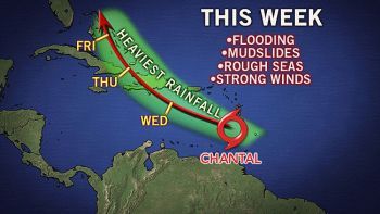
(STATE COLLEGE, PA AccuWeather.com) - AccuWeather.com reports as Chantal tracks west-northwestward across the Caribbean, the greatest threat from the tropical storm will be from flooding this week.
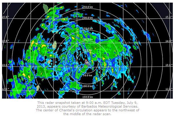
The Windward islands will experience tropical storm conditions Tuesday, followed by similar conditions over parts of the U.S. Virgin Islands and Puerto Rico Tuesday night and Wednesday. Haiti and the Dominican Republic would be impacted by Chantal later Wednesday into Thursday.
While fast movement of Chantal will limit the amount of rain on the smaller islands, large mountains on the Greater Antilles will squeeze out tremendous moisture, regardless of the forward speed of the storm.
In most situations similar to Chantal, the worst of the rain and heaviest squalls tend to occur near, east and northeast of the storm track. The conditions tend to "follow" the storm as it moves along.
 |
All interests from the Lesser Antilles to eastern Cuba should be prepared for mudslides and flash and urban flooding.
Chantal will also generate heavy seas and rough surf along its path.
There is the potential for damaging winds and power outages, especially if the tropical system reaches hurricane status along its journey.
Late in the week, Chantal is forecast to turn on a more north to northwest path, which will take it over the Bahamas and waters just east of Florida.
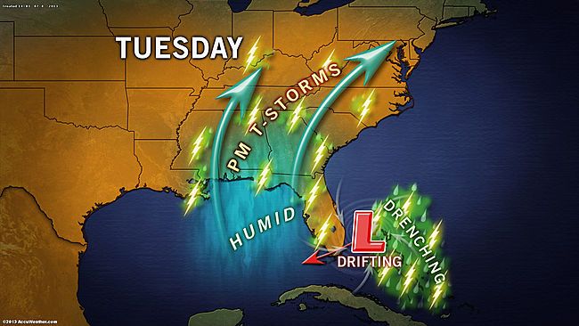
The area from the Bahamas to the Florida Peninsula will first be hit by a non-tropical system moving in from the east Tuesday into Wednesday. This storm in the upper atmosphere is forecast to pack its own torrential downpours, locally heavy squalls and gusty thunderstorms.
 |
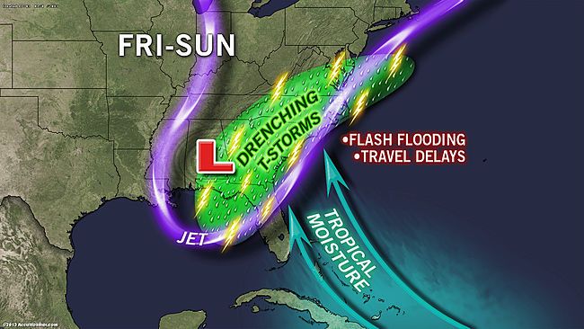
Rainfall from either of the two or both systems brings a risk of urban and low-lying area flooding.
Eventually, moisture from either or both systems will be absorbed over the mainland United States, adding to the mosaic of daily showers and thunderstorms, as well as the risk of flash and urban flooding problems.
 |
While rainfall during the summer season is essential for water supplies in the tropics, parts of the Caribbean have already received double their normal rainfall since June 1. Much of the landscape is primed for excessive runoff and flooding.
At San Juan, Puerto Rico, 13 inches of rain has fallen since June 1, compared to a normal rainfall of around 6.50 inches for the period. At St. Croix, Virgin Islands, nearly 8 inches of rain has fallen during the same period, compared to an average of just under 3 inches.
By Alex Sosnowski, Expert Senior Meteorologist for AccuWeather.com
 |
 |
 |
Articles for July 8, 2013 | Articles for July 9, 2013 | Articles for July 10, 2013


Quick Links
DINING
Willamette UniversityGoudy Commons Cafe
Dine on the Queen
Willamette Queen Sternwheeler
MUST SEE SALEM
Oregon Capitol ToursCapitol History Gateway
Willamette River Ride
Willamette Queen Sternwheeler
Historic Home Tours:
Deepwood Museum
The Bush House
Gaiety Hollow Garden
AUCTIONS - APPRAISALS
Auction Masters & AppraisalsCONSTRUCTION SERVICES
Roofing and ContractingSheridan, Ore.
ONLINE SHOPPING
Special Occasion DressesAdvertise with Salem-News
Contact:AdSales@Salem-News.com

Terms of Service | Privacy Policy
All comments and messages are approved by people and self promotional links or unacceptable comments are denied.
[Return to Top]
©2025 Salem-News.com. All opinions expressed in this article are those of the author and do not necessarily reflect those of Salem-News.com.