
Publisher:
Bonnie King
CONTACT:
Newsroom@Salem-news.com
Advertising:
Adsales@Salem-news.com

~Truth~
~Justice~
~Peace~
TJP
Jan-18-2011 04:23

 TweetFollow @OregonNews
Western Oregon Sees Several Floods and Landslides
Tim King Salem-News.comOregon drivers need to continue to use caution in several areas.
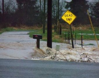 Tillamook-area flooding and landslide. Oregon State Police photo. |
(SALEM, Ore.) - Oregon's swelling rivers have caused problems over much of the western half of the state. Landslides and washouts have halted traffic in several locations.
Tillamook
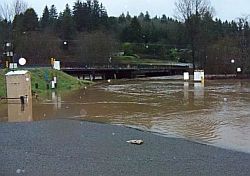
Tillamook was the scene of flooding and what Oregon State Police (OSP) troopers described as a major landslide that still has Highway 6 closed.
OSP Sergeant Greg Plummer says the Tillamook slide started at the top of a ridge north of Highway 6 where the main power supply lines run toward Tillamook.
"The entire hillside slid south across Highway 6 and into the Wilson River."
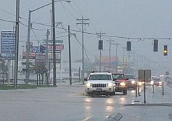
He says those on scene surveying the mess believe mud and trees covering the highway will keep it closed for at least two days.
Power and phone service was knocked out in the immediate area of the slide, Plummer said.
"Several smaller slides on Highway 6 and Highway 101, as well as flooding issues throughout the county, have kept transportation and public safety agencies very busy."
Tillamook has received national coverage in the past for extreme flooding the the Wilson River Highway is notorious for landslides.
Take due caution when driving in any of the affected areas.
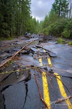
Sandy and Zigzag Rivers
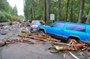 Photos by Gary Randall with Precision Artists |
Sunday we showed you video footage of the raging Sandy River which was cresting its banks over the weekend.
That was shot by Gary Randall with Precision Artists, who also sent the current Sandy River photos.
He said at the time that residents near the Sandy River were frantically filling sandbags in an effort to save their properties from rising flood waters.
He also speculated that Lolo Pass Road would wash out and residents had to decide if they were willing to have their vehicles stranded on their property or evacuate. Gary Randall told Salem-News Monday, "Lolo Pass Road is closed and the new bridges over the Zigzag River are both closed until further notice."
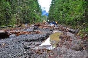
He says the biggest hope remains in repairing a particular section of a local road.
"If the road crew can get the road repaired from Barlow Trail Road on up Lolo Pass, which is the bad part, the people that can’t get in or out except by foot will be able to get back in to their homes via Barlow Trail Road."
Until now he says, residents have had to walk in and out for supplies and have no water or electricity. "It sounds like it will be a long time until the Zigzag River bridge at Zigzag is reopened."
And with all of this come questions about whether an expensive recent project was built stoutly enough to handle the river it spans. Randall said, "The bridge is only a couple of years old, do you think that the engineers underestimated the river?"
Three Rivers Highway
Another area that took damage is Oregon Highway 22W (Three Rivers Hwy). Oregon Dept. of Transportation (ODOT) crews reported Monday that the road was open to a single lane of travel at milepost 12, between Sheridan and the coast.
They say approximately 50 feet of the westbound lane has eroded from the heavy rains. It was reported that the sinkhole measures 4 feet by 20 feet by 4 inches deep.
A press release stated, "Flaggers will control travel in alternating directions through the night and into tomorrow. ODOT will have an update on the conditions tomorrow, as soon as additional information is available."
Santiam Highway
ODOT reports that all lanes are now open on US 20 (Santiam Hwy) at milepost 44, approximately 17 miles east of Sweet Home, where a significant slide occurred Sunday.
"ODOT crews have been successful in clearing debris from a large slide, several smaller slides and two plugged culverts. The highway is now fully open to motorists."
Officials with ODOT say motorists should remain mindful that the hillsides are saturated from heavy rains.
"Motorists should travel alertly at reduced speeds and be ready to respond to slide activity or eroded roadways."
Eddyville nad Siletz River
ODOT Crews in Lincoln County responded to OR 180 (Eddyville-Blodgett Hwy) at milepost 6 after high water closed the highway Sunday night. That is now open, however OR 229 (Siletz Hwy) remains closed at milepost 9.
Seaside
Highway crews say U.S. 101 south of Seaside at Beerman Creek is open to all traffic. However, there was still high standing water Monday which requires restrictions of 5 miles per hour, ODOT related in a news release.
"Motorists are urged to drive slowly and carefully through areas of high standing water. ODOT will be monitoring water levels. Continued rain and high tide may require additional restrictions. Please go to TripCheck.com for the latest information."
Drivers again are reminded to travel very slowly through water; going faster reduces your control and if water is splashed hard enough to get inside of your car's engine, it will be destroyed on the spot. The best advice is to follow the signs and go slow, always watching for flaggers, police and highway workers.
Articles for January 17, 2011 | Articles for January 18, 2011 | Articles for January 19, 2011
Quick Links
DINING
Willamette UniversityGoudy Commons Cafe
Dine on the Queen
Willamette Queen Sternwheeler
MUST SEE SALEM
Oregon Capitol ToursCapitol History Gateway
Willamette River Ride
Willamette Queen Sternwheeler
Historic Home Tours:
Deepwood Museum
The Bush House
Gaiety Hollow Garden
AUCTIONS - APPRAISALS
Auction Masters & AppraisalsCONSTRUCTION SERVICES
Roofing and ContractingSheridan, Ore.
ONLINE SHOPPING
Special Occasion DressesAdvertise with Salem-News
Contact:AdSales@Salem-News.com

googlec507860f6901db00.html


Terms of Service | Privacy Policy
All comments and messages are approved by people and self promotional links or unacceptable comments are denied.
[Return to Top]
©2025 Salem-News.com. All opinions expressed in this article are those of the author and do not necessarily reflect those of Salem-News.com.