Publisher:
Bonnie King
CONTACT:
Newsroom@Salem-news.com
Advertising:
Adsales@Salem-news.com

~Truth~
~Justice~
~Peace~
TJP
Dec-21-2015 01:53

 TweetFollow @OregonNews
High Wind Warning Issued for NW Oregon and SW Washington by NWS
Salem-News.com WeatherA wind storm is expected for much of NW Oregon and SW Washington on Monday. Winds will be increasing to 25 to 35 mph with gusts 50 to 60 mph.
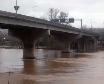
 The Willamette River in Salem is already at flood stage. Photo by Bonnie King, Salem-News.com |
(PORTLAND, Ore.) - The next strong storm expected for Northwest Oregon and Southwest Washington is being forecast to be more of a wind storm and less of a heavy rain producer than earlier thought.
This storm is expected to produce a period of heavy rain Monday morning and early Monday afternoon, but the associated cold front is forecast to move south of northwest Oregon by late Monday – sooner than previously thought.
This will limit the duration of the heavy rain and lessening the risk of flooding on area rivers.
However, the rain may be heavy enough at times for some localized urban flooding. With rivers already running high, this amount of rain will still produce significant rises on several rivers. Thus, this situation still bears watching should rainfall details change again.
The National Weather Service has issued a High Wind Warning, which is in effect from 9 am to 4 pm PST Monday for the central and south Willamette Valley, and north Oregon Cascade foothills.
A High Wind Warning means a hazardous high wind event is expected or occurring, sustained wind speeds of at least 40 mph or gusts of 58 mph or more can lead to property damage.
Winds will be south to southwest winds increasing to 25 to 35 mph with gusts 50 to 60 mph. Winds will develop not long after sunrise, with peak winds between 9 am and 3 pm.
Winds will make traveling along the Oregon coast extremely hazardous. Saturated soils combined with the unusually strong winds will likely damage or even uproot some trees causing damage and disrupting power.
Specific areas where these conditions can be expected include Salem, McMinnville, Eugene, Springfield, Corvallis, Albany, Lebanon, Sandy, Estacada and Sweet Home, encompassing the Central Willamette Valley, Northern Oregon Cascade Foothills and South Willamette Valley. The threat of flooding in southwest Washington and northwest Oregon lessens for Monday and Tuesday.
For up to the minute information on weather and river forecasts, stay tuned to WEATHER.GOV/PORTLAND.
Articles for December 20, 2015 | Articles for December 21, 2015 |


Quick Links
DINING
Willamette UniversityGoudy Commons Cafe
Dine on the Queen
Willamette Queen Sternwheeler
MUST SEE SALEM
Oregon Capitol ToursCapitol History Gateway
Willamette River Ride
Willamette Queen Sternwheeler
Historic Home Tours:
Deepwood Museum
The Bush House
Gaiety Hollow Garden
AUCTIONS - APPRAISALS
Auction Masters & AppraisalsCONSTRUCTION SERVICES
Roofing and ContractingSheridan, Ore.
ONLINE SHOPPING
Special Occasion DressesAdvertise with Salem-News
Contact:AdSales@Salem-News.com

Terms of Service | Privacy Policy
All comments and messages are approved by people and self promotional links or unacceptable comments are denied.
[Return to Top]
©2025 Salem-News.com. All opinions expressed in this article are those of the author and do not necessarily reflect those of Salem-News.com.