Publisher:
Bonnie King
CONTACT:
Newsroom@Salem-news.com
Advertising:
Adsales@Salem-news.com

~Truth~
~Justice~
~Peace~
TJP
Aug-09-2006 10:43

 TweetFollow @OregonNews
Crews Battling Fires in Mt. Hood National Forest
TIMBERLINEThe Northwest Oregon Interagency Incident Management Team assumed control of crews in the Forest.
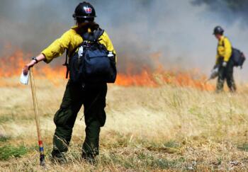
 Hot shot crew Photo courtesy: newwest.net |
(TIMBERLINE) - A series of fires continue to burn on Mt. Hood National Forest as a result of a lightning storm that swept through the area the evening of August 7th. The main area of concern is on the north east end of the Forest where an estimated 200 acre fire and several smaller fires are burning.
The fires are being referred to as the Mt. Hood Complex.
The largest fire in the Mt. Hood Complex is Bluegrass Ridge Fire on the east side of the Mt. Hood Wilderness, north of Elk Meadows and south of Nottingham Campground.
At this time there are no crews on the ground working on this fire. East of Highway 35 near Gumjawac Saddle another fire is estimated at 50 acres and is burning into the Badger Creek Wilderness.
A type I helicopter is dropping water on the fire to slow its spread and the Zigzag Interagency Hotshot crew is on the ground working on this fire.
There are 7-11 spot fires in the Badger Creek Wilderness.
Four engine crews are working on other small fires to the north of Badger Creek Wilderness.
The Northwest Oregon Interagency Incident Management Team is on the Forest and will assume command of the fire at 6:00 AM Wednesday.
The following additional resources have been ordered:
8 Type I crews Redmond Hotshot Crew 1 Fixed wing plane 1 Type I helicopter 1 Type III helicopter A Temporary Fire Restriction is in place.
Road Closures:
Highway 35 between White River Snow Park and Parkdale Forest Highway 17 from junction with 660 spur (vicinity of Gibson Prairie) south to Forest Road 1720 Forest Highway 27 at junction with Forest Road 2730 to Forest Highway 44 Forest Highway 44 from junction with Forest Road 4430 west to State Highway 35 Forest Highway 48 from junction with Forest Road 4860 west to State Highway 35, except travel will be permitted on Forest Highway 48 to Forest Highway 43 and then west to US 26. Cloud Cap Road at Cooper Spur Ski Area to Cloud Cap and Tilly Jane Forest Road 2730 from 2730 to Forest Road 2710 at Bonney Crossing Campground Forest Road 3550 Recreation closures:
Nottingham Campground Sherwood Campground Cloud Cap/Tilly Jane Timberline Trail #600 from McNeil Point to Timberline Lodge All trails between the Timberline Trail #600 and Highway 35 Badger Creek Wilderness Timberline Lodge and other Government Camp businesses are not affected by the fires and remain open for business. Access from Highway 26 is open. Access from Hood River to Government Camp via Highway 35 is closed and an alternate route must be used. The Pacific Crest Trail #2000 also remains open.
Articles for August 8, 2006 | Articles for August 9, 2006 | Articles for August 10, 2006
Quick Links
DINING
Willamette UniversityGoudy Commons Cafe
Dine on the Queen
Willamette Queen Sternwheeler
MUST SEE SALEM
Oregon Capitol ToursCapitol History Gateway
Willamette River Ride
Willamette Queen Sternwheeler
Historic Home Tours:
Deepwood Museum
The Bush House
Gaiety Hollow Garden
AUCTIONS - APPRAISALS
Auction Masters & AppraisalsCONSTRUCTION SERVICES
Roofing and ContractingSheridan, Ore.
ONLINE SHOPPING
Special Occasion DressesAdvertise with Salem-News
Contact:AdSales@Salem-News.com

googlec507860f6901db00.html


Terms of Service | Privacy Policy
Comments are Closed on this story.
[Return to Top]
©2025 Salem-News.com. All opinions expressed in this article are those of the author and do not necessarily reflect those of Salem-News.com.